")
Starting tomorrow (September 16th) at noon, the restricted area around the Bearhole Lake wildfire of note will be shrinking back from the borders set on September 5th.
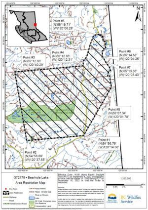
In a news release, the Prince George Wildfire Centre set the following boundaries:
“The order applies to crown land within the geographic boundary outlined below and shown on the map provided:
- Starting at the junction of Boot Lake Road and Highway 52; then heading South along Highway 52 for 31 km to the junction of Highway 52 and Redwillow Forest Service Road; then heading West for 27.5 km to a point west of Hambrook Lake; then heading North for 29.75 km to a point east of Highway 52, 11 km along Hourglass Road; then heading East for 30 km to the starting point at the junction of Boot Lake Road and Highway 52.”
They say the only allowable reasons for a person to enter this fire zone are:
- Travelling to or from his or her residence;
- Using a highway as defined in the Highway Act;
- Travelling through or entering the area as a person acting in an official capacity; or
- Travelling through or entering the area for an approved purpose of supporting wildfire suppression activities.
Failure to comply with these restrictions could result in a $1,150 fine.
Below is the previous map of the restricted area, for comparison.
Something going on in the Nechako Valley area you think people should know about?
Send us a news tip by emailing [email protected].